It’s that time of year! Usually I’m one of those people that bemoan the loss of summer, but the colder months are actually my favorite for Tennessee hiking. Fewer crowds, fewer bugs, much less sweating. Plus, there are only so many days I can sit cozy under a blanket before I go stir crazy (especially since my version of staying at home also includes small children that always find a way to call my name the second I get settled and focused on anything).
So if you, too, find yourself going stir crazy and craving a deep breath of cool, crisp air, that’s your sign to get outside and get moving. Here are ten of my favorite hikes in the middle Tennessee area that will take you to a wide variety of landscapes. I’ve done all of these with my kids, but if you don’t have tiny legs accompanying you, they’re still great hikes – and in most cases, can be extended for even longer distances.
Looking for the best summer hikes? Check out my “11 Nashville-Area State Park Day-Hikes for Summer (with or without kids!)“
And if you’re looking for more details on any of the locations listed, check out full park details on my Tennessee State Parks page!
- 1. Base of Falls Trail @ Fall Creek Falls State Park
- 2. River Trail @ Burgess Falls State Park
- 3. Enclosure Trail @ Old Stone Fort State Park
- 4. Highland Rim Nature Trail @ Edgar Evins State Park
- 5. Spring Creek Trail @ Henry Horton State Park
- 6. Stone Door Trail @ Savage Gulf State Park
- 7. Cedar Forest Trail @ Cedars of Lebanon State Park
- 8. High Ridge & Shoreline Trails @ Bledsoe Creek State Park
- 9. Ganier Ridge Trail @ Radnor Lake State Park
- 10. Day Loop Trail @ Long Hunter State Park
1. Base of Falls Trail @ Fall Creek Falls State Park
Closest town/city: Spencer
Hiking distance: 0.35 mile out-and-back (0.7 miles total)
If you live in Tennessee and haven’t heard of Fall Creek Falls, I’m surprised! At 256 feet, it’s the highest waterfall east of the Mississippi. While there’s plenty to see at Fall Creek Falls for a day visit, it could also easily be a week-long trip destination. In fact, just one quick visit will most likely leave you wanting a longer stay!
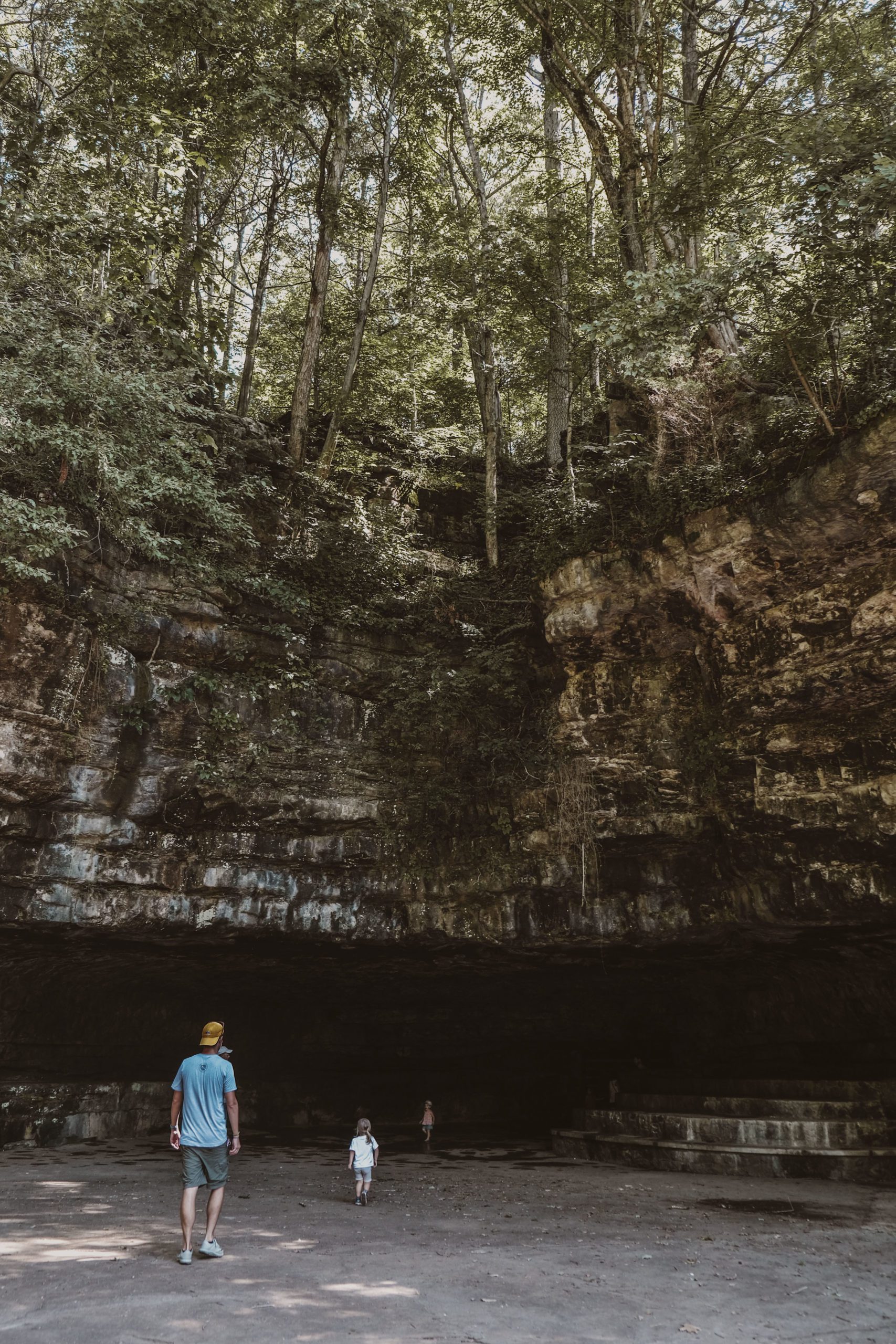
Because there’s so much to see and do, there’s no bad time of year to visit FCF, but I think waterfalls in winter are so underrated. One of the most memorable hikes I’ve had in the last decade was the Base of Falls Trail. You begin at the Fall Creek Falls Overlook which provides easy parking. Around the corner you’ll find the sign for the Base of Falls Trail. There is a warning sign about the steep incline; it can be hard on the knees going down, and it’s quite a climb back up! However, it’s not often you’re face-to-face with a thundering fall. It’s overwhelming in the best way and so worth the steep climb.
2. River Trail @ Burgess Falls State Park

Closest town/city: Sparta
Hiking distance: 0.75 mile one way (plus at least 0.5-mile return)
Burgess Falls is one of a handful of waterfalls about an hour east of Nashville. This park is one of the smallest state parks in the system, and it’s open for day-use only. The trailhead parking lot has picnic and restroom facilities and a pretty good playground, too. There are technically three trails on the park map, but you’ll want to stay close to the water for the best experience.
The River Trail begins at the parking lot and follows the shore for a moderate hike past three separate waterfalls before reaching the observation deck overlooking the towering Burgess Falls. Past here, there’s one final trail segment that heads downhill, closer to the water. You can return the way you came or, for an easier walk, follow the Access Trail that leads directly to the parking lot. The shorter distance and wow factor make this a great hike for kids; my 2-year-old was able to handle it without a problem.
3. Enclosure Trail @ Old Stone Fort State Park

Closest town/city: Manchester
Hiking distance: 1.4 mile loop
Old Stone Fort is a State Archaeological Park, which means part of its purpose is to preserve the ruins that have been found at the site. The old stone fort, an enclosure built by Native Americans, dates to the Middle Woodland era (1,500-2,000 years ago) and is believed to have been a space for sacred ritual as opposed to an actual defensive fort. It also happens to have a really nice location on the Duck River!
The best trail at the park is the Enclosure Trail, which begins just behind the museum and visitor’s center with a pretty sweet view of the river. You can choose which direction to take the loop; I usually opt for the counter-clockwise path (begin right at the fork) to enjoy the water view for the first part of the hike. You’ll pass two impressive waterfalls and the remnants of an old 19th-century mill before you veer into grassy fields. To add mileage, you can connect to the Moat or Backbone Trails.
4. Highland Rim Nature Trail @ Edgar Evins State Park

Closest town/city: Buffalo Valley
Hiking distance: 1.4 mile (or 2-mile?) loop
Edgar Evins is situated on Center Hill Lake, one of Tennessee’s many TVA-built reservoirs. Though I love the lake especially in the summer (boat life), when the trees are ablaze with fall colors, it’s an absolutely beautiful blend of foliage and water. This hike has a lot packed into a relatively short distance. It’s satisfying without being entirely exhausting.
The trail begins right outside the park’s visitor center (which you shouldn’t miss; it has a pretty cool observation deck), but here’s the confusing part: all the park guides measure the trails distance as 1.35 miles, but the trailhead sign outside the visitor center distinctly says “2 miles.” I honestly don’t know which one is accurate, so let’s just split the difference! The start of the trail is actually its highpoint before descending into forest. About halfway through, you run along the lake shore where a quick trek off the beaten path leads to a gorgeous lake view and nice spot for a snack, rest, or rock skip. The remainder of the trail climbs back through the forest and zig-zags up the ridge for a more strenuous finish.
5. Spring Creek Trail @ Henry Horton State Park

Closest town/city: Chapel Hill
Hiking distance: 1.7 mile out-and-back
Henry Horton is one of those parks with tons of amenities – like a restaurant, golf course, and lodge – so you can make a whole vacation out of your stay, but it’s also a solid destination for a day hike (and located just about an hour outside Nashville). It has a solid trail system of loops that allow you to customize a route to get in however much mileage you’re feeling at the moment. Plus, there’s enough variety that you can come back on another day for an entirely different experience.
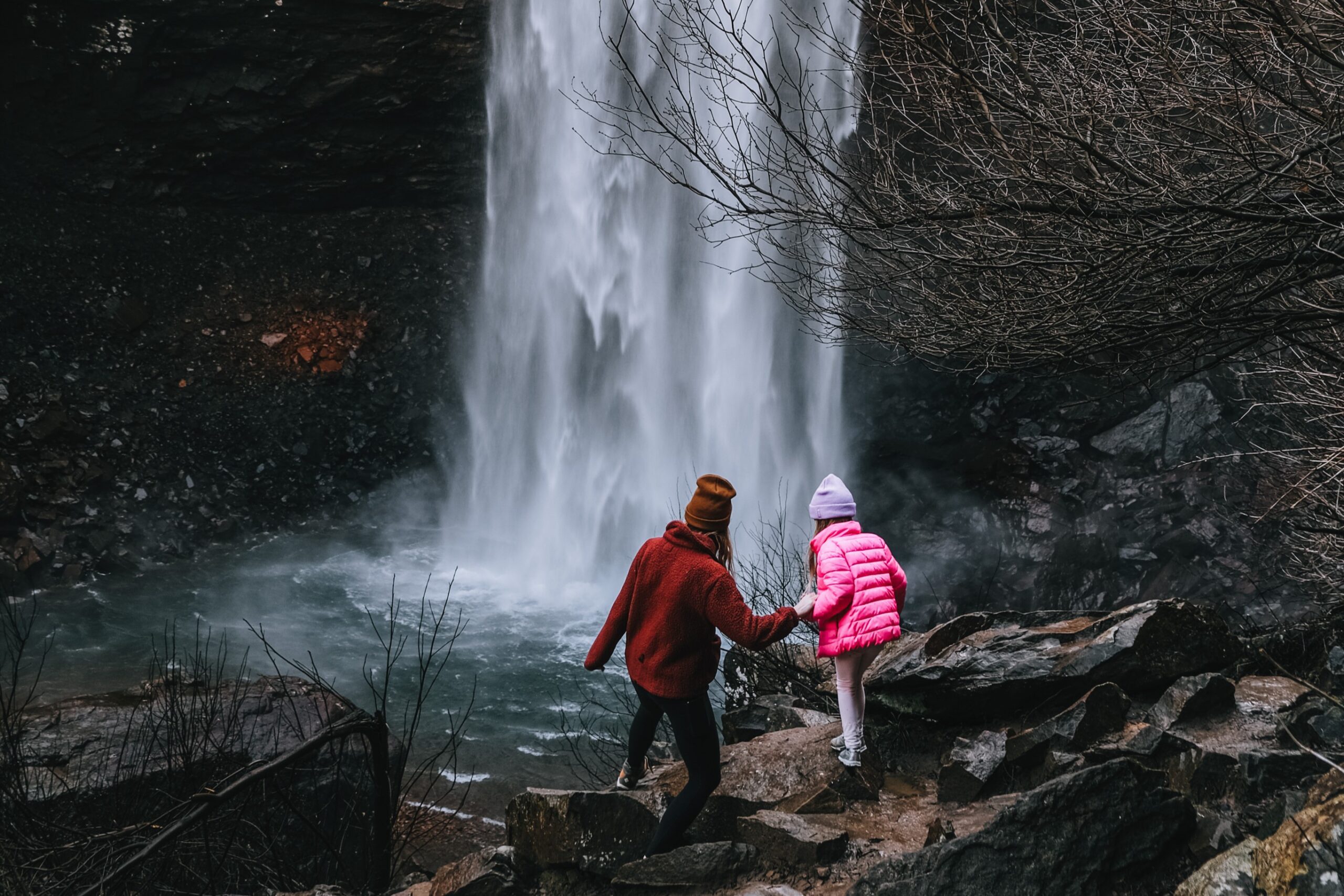
I love water features in the winter, so the Spring Creek Trail is a good one for the quieter, less buggy months. Park at the Wilhoite Mill Trailhead, and follow the Willhoite Mill Trail for 0.2 miles until it connects to the Spring Creek Trail. The trail then follows the ridge alongside its eponymous creek. There is hardly any elevation change, and you can easily turn around at any point if you have smaller companions. My favorite spot is on top of the huge, flat rock faces that spread to the edge of this small cliff, the creek dropping 20 feet below. Winter is the perfect time for this hike, when the trees are bare and foliage doesn’t block the view of the water. It’s also fun to seek pops of color when most plants are dormant, especially in the luscious green moss coating the rocks.
6. Stone Door Trail @ Savage Gulf State Park

Closest town/city: Beersheba Springs
Hiking distance: 0.9 mile out-and-back (1.8 miles total)
I first encountered this trail when I was 13-years-old on a youth group trip, and I’ve recommended it ever since. It’s located in what was previously known as South Cumberland State Park, which was so massive it has since been split into three distinct parks. Savage Gulf is a dream park for serious hikers; it boasts an impressive 17 different trails covering all lengths and levels of difficulty.
The Stone Door hike is definitely the most pay-off for the smallest amount of work. The trail begins at the end of Stone Door Road where there’s a ranger station, parking lot, and restroom/water facilities. Then, it’s a short and flat path, and the first quarter of the trail is paved. Around the point the pavement ends, you’ll reach the Laurel Gulf Overlook, a viewing deck with an expansive panoramic view. The trail’s official turn-around spot is the Great Stone Door, a 10-foot wide, 100-ft deep crack in the bluffs. If you wanted, you could continue along the ridge or down into the gulf for a much longer hike.
Just to note: the overlooks are not for those wary of heights; there is no guardrail protection from the cliff’s sheer drop-off, so be extra mindful if you are hiking with kids or dogs. There is, however, plenty of room away from the edge to take in the surrounding views; they’re some of the most gorgeous I’ve seen in Tennessee.
7. Cedar Forest Trail @ Cedars of Lebanon State Park

Closest town/city: Lebanon
Hiking distance: 1.9 mile loop
It may look like just a forest, but Cedars of Lebanon is actually home to a rare cedar glade ecosystem formed by limestone that is so close to the surface where the soil is very thin. As a result, these glades in Middle Tennessee are home to some plant and wildflower species that don’t grow anywhere else in the world!
The Cedar Forest Trail has two trailheads – one just behind the visitor center, and the other deeper in the park near the lodge and visitor center (add 0.3 miles to your distance if you pick the latter starting point). The trail follows a mostly-flat path through the limestone glades and cedar forest. Make it an exploration by following this winter recommendation we received from a park ranger: see how many different shades of green you can find in the moss that blankets the rocks and ground.
8. High Ridge & Shoreline Trails @ Bledsoe Creek State Park

Closest town/city: Gallatin
Hiking distance: approx. 2.5 mile loop (or more or less)
To Nashvillians, I think Bledsoe Creek is often overlooked. It’s very close to Gallatin, which means you don’t even need to use a whole day to enjoy a day hike. It’s much smaller and less crowded than Radnor Lake but has similar appeal – a lake that brings abundant wildlife surrounded by quiet, forested trails. It’s a great spot for a quick hike (and frequent visits) if you live nearby.
The High Ridge Trail combined with the Shoreline Trail offer a satisfying distance with a complete overview of the park’s landscape. Begin by parking at the visitor center and climb the short connector that takes you up to the High Ridge Trail. Follow the path through forest alongside a rolling meadow for about a mile to reach the start of the Shoreline Trail. Here begins the descent to the ridge perched just above the lake shore, following the water’s edge to a boat launch and dock. Here, you can veer onto the paved road back to your starting point (about 0.5 miles) or continue along the trail for another approximate mile.
9. Ganier Ridge Trail @ Radnor Lake State Park

Closest town/city: Nashville
Hiking distance: at least 2.5 mile one-way (various paths back)
Radnor Lake is one of Nashville’s (not-so-hidden) gems of an outdoor space. It’s beautiful and tucked into a quiet residential area, but if it’s a beautiful day out and you’re thinking of heading to Radnor for a hike, the rest of Nashville probably is, too, no matter the season. Fortunately, even if the parking lots are full, there are several trails to explore, and it’s easy to still feel the solitude.
The park’s longest trail is the 1.65-mile Ganier Ridge trail, though, on paper, this mileage is misleading; it requires more miles to reach the trail in the first place. Even though this route requires a walk along the lake to reach, the trail itself gives you a different perspective by offering dense forest, elevation, and a couple viewpoints. Still waters and quiet forests – it’s the best of both worlds! You can quickly connect to this trail from either parking lot. There are moderate climbs through the woods, and you can double-back to return to your starting part. Or, create your own return by looping on flatter land around the lake.
10. Day Loop Trail @ Long Hunter State Park

Closest town/city: Mt. Juliet
Hiking distance: 4 mile loop
On the shores of Nashville’s largest and most popular lake (Percy Priest) you’ll find Long Hunter State Park. The park actually consists of three separate sections on the lake’s easternmost shores, and each offers their own hiking opportunities. While Long Hunter’s trails are great any time of year, they’re always a bit quieter in the fall and winter months and, being on the water, much less buggy!
The Day Loop Trail is nearly, in my opinion, the perfect hike. It makes you sweat without being entirely exhausting; it’s the perfect distance without dragging on; and it has enough climbs to make you feel accomplished without dreading the next. The first half mile shares a path with the longer Volunteer Trail (a one-way 5.5-mile trail leading to backcountry camping) through wooded lowlands. Take the left fork towards the water and follow trail markers to stay on the loop. The next 2+ miles follow the lake shore, climbing and falling as the elevation changes. The trail moves away from the shoreline for the hike’s highest elevation change and through the woods for another .8 miles to finish the loop, and return to the half-mile path leading to the parking lot.
A note about parking: the lot is very small and in a residential area with no spillover parking. Your best bet would be to hike early, on weekdays, or in the off-season.