If you’ve known or followed me for any of the past 4+ years, you’ll already know I have a relationship with my local Tennessee State Parks. What began just before COVID as my own personal project of visiting, photographing, and writing about all of our state parks has since turned me into a perceived park “expert” by family, friends, and local acquaintances and even led to a professional freelance relationship with the TNSP organization itself!
This blog, though, is where it all began, with our first-hand accounts and personal experiences. Yesterday, I posted on Instagram a quick list of some of my top summer state park hikes, and it had enough shares to make me think this would be a good guide to have a permanent spot somewhere online. And since I’m now on break from school and again have a little bit of time on my hands, here’s a list of 10+ great hikes near(ish) Nashville to explore this summer!
Looking for the best fall and winter hikes? Check out my “10 Middle Tennessee State Park Day-Hikes for Fall and Winter!”
The below guide is specific to hiking trails. If you want the full details on each of these parks, click here!
- 1. Lake Trail @ Radnor Lake State Park
- 2. Hidden Lake @ Harpeth River State Park
- 3. Couchville Lake Trail @ Long Hunter State Park
- 4. The Narrows @ Harpeth River State Park
- 5. Wildcat to Ore Pit Trail @ Montgomery Bell State Park
- 6. Old Main Street @ Port Royal State Historic Park
- 7. Short Loop Trail @ Dunbar Cave State Park
- 8. Gorge Trail @ Cummins Falls State Park
- 9. Downstream Trail @ Rock Island State Park
- 10. Spring Creek Trail @ Mousetail Landing State Park
- 11. Pioneer Short Loop Trail @ Cumberland Mountain State Park
1. Lake Trail @ Radnor Lake State Park

Distance from Nashville: 11 miles
Closest town/city: Nashville city-center
Hiking distance: 1.35 miles + another 1 paved mile along the road back to the start (click for map)
I still so often forget that Radnor Lake is a state park; it has always been this wonderful oasis tucked away in a residential neighborhood, a real treat to folks like me who grew up nearby. Part of that is intentional, as there are no road signs advertising it to tourists, and overnight accommodations don’t exist. Instead, it’s a day-use-only, highly restricted hub of wildlife observation and research. That being said, it has a huge community of supporters and about 10 separate hiking trails.
In my years, I’ve hiked most, if not all, of the trails, but the Lake Trail was our most recent that offered a solid, gratifying hike that was achievable by little legs. Begin this route at the Visitor Center on the park’s western side. [There are two parking areas, and the trails are about as equally accessible from each, but the east lot is much smaller.] Once the trail gets going, past the dam, it will quiet down and meander along the lake’s edge with only small inclines. Wildlife is abundant at Radnor Lake, so keep your eyes and ears peeled!
2. Hidden Lake @ Harpeth River State Park

Distance from Nashville: 18 miles
Closest town/city: Pegram
Hiking distance: a minimum of 1 mile, possibly more (click for map)
Harpeth River State Park is a unique one because it’s made up of a collection of nine segmented areas. There’s no unifying Visitor Center or park amenities. Instead, it’s just a series of spots that allow visitors to explore the land along 40 miles of the Harpeth River.
The most visited segment of the park is Hidden Lake where you’ll find five different trails that cover a total of about 3 miles. From the parking lot, follow the Bluebird Trail until it meets up with the Ridge Loop Trail. Early on, there’s waypoint where two additional trails intersect. You can continue on the loop for a hearty, moderate hike, but you want to be sure to check out the off-shooting Hidden Lake Trail. You’d never know it from a casual walk, but this area was once home to a 1930s resort that offered swimming, fishing, water rides, and a clubhouse. You can still see part of the old concrete floor, a relic of the past that amazes me every time because it’s so hard to imagine when you’re present!
3. Couchville Lake Trail @ Long Hunter State Park

Distance from Nashville: 25 miles
Closest town/city: Mt. Juliet
Hiking distance: 2 miles (click for map)
Long Hunter is another park that seems a bit segmented as it’s spread along the shores of Percy Priest Lake. In fact, many locals (myself once included) probably don’t even realize these are state park lands, as we’re more familiar with the activities on the water than off of it. The park makes it very easy to access and enjoy the water, if if you don’t have your own personal motorboat!
An easy hike that we’ve done many times—and taken many visitors to explore—is the Couchville Lake Trail, a flat, paved, shaded loop near the park’s Visitor Center. The foliage is comfortably dense, and the lakeshore always remains in view. There are small fishing docks scattered along the trail and a picnic provides a stopping point about halfway through. Be sure to walk the path in the counter-clockwise direction (beginning, from the parking lot, to the right) so that the long, wooden bridge that crosses the water rewards the final stretch of your hike!
4. The Narrows @ Harpeth River State Park

Distance from Nashville: 27 miles
Closest town/city: Kingston Springs
Hiking distance: about 1.6 miles to cover all trails (click for map)
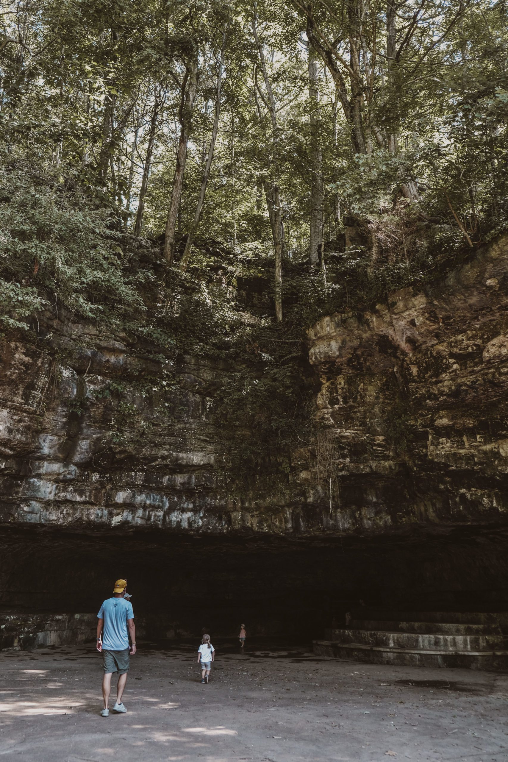
A very satisfying day trip can be found at different section of Harpeth River State Park called The Narrows. You park near the Harris Street Bridge (there’s signage to help guide!) and follow a short trail through the woods and alongside a towering rock face. When you reach a fork in the road, there are two paths to take, and you should definitely do both! On the left, follow steps for a .5-mile roundtrip climb up the Bluff Trail. The path is narrow and uneven with steep drop-offs—be extra mindful if you have kids with you—but the views are amazing! Once you’ve descended, head to the remaining fork for the .4-mile roundtrip Tunnel Trail. Here you’ll find an early 19th-century tunnel excavated through the ridge to connect the riverbeds and source a wrought iron forge.
5. Wildcat to Ore Pit Trail @ Montgomery Bell State Park

Distance from Nashville: 35 miles
Closest town/city: Dickson
Hiking distance: around 3 miles (click for map)
Montgomery Bell is a park with a lot of amenities! In addition to the nature-based offerings you’d expect of a state park, there’s also a lodge, restaurant, swimming pool, and golf course. Like many other Tennessee State Parks, its origin lies as a recreation area built by the Depression-era programs of the Works Progress Administration and Civilian Conservation Corps.
We took the Wildcat Trail to the Ore Pit Trail on recommendation of a park ranger. The western half of the Wildcat Trail begins at the Visitor Center and climbs along a low ridge through wonderfully dense foliage for about 2/3 of a mile until it connects with the 1.5-mile Ore Pit Trail. At the junction, head right to follow this trail’s loop in a counter-clockwise manner, and you’ll cross a paved road that houses replica buildings of the first Cumberland Presbyterian Church and the reverend’s log cabin. The church still hosts Sunday services during the summer!
6. Old Main Street @ Port Royal State Historic Park

Distance from Nashville: 45 miles
Closest town/city: Clarksville
Hiking distance: <1 mile (click for map)
You’ll notice that Port Royal is named a State Historic Park, and it’s designated as such because it’s preserving a piece of history, not just nature. The town of Port Royal was established early in Tennessee’s history as a state as a port that eventually led commerce downriver to New Orleans. An entire town developed around it, but nearly all evidence of that community has disappeared.
Here’s a spot you need to plan for a guided tour (book reservations online), because you’d miss all the importance of what you’re seeing without it! The tour will begin at the Visitor Center which is housed in an old building that was once a general store and Masonic Lodge. When we visited in the summer of 2020, the Park Rangers were working themselves on a full restoration of the building by hand that has since been completed! Across the street you’ll find Old Main Street—hardly a hub of commerce anymore!—and can follow it to a nice photo op at the Pratt Truss Bridge. For more history and hiking, you can venture to a nearby portion of the Trail of Tears; Port Royal was the route’s final stop in the state on the Cherokee’s forced exodus west.
7. Short Loop Trail @ Dunbar Cave State Park

Distance from Nashville: 47 miles
Closest town/city: Clarksville
Hiking distance: <1 mile (click for map)
Dunbar Cave is one of the most unique state parks in our system. The cave itself is cool enough, but it’s got a fascinating history that spans thousands of years – from its use as a Mississippian-era ceremonial space to a 20th-century big band nightclub. You will definitely want to hop on one of the park’s guided tours if you can. In the summer months, there are a multitude of various cave tours (book reservations online) and other guided hikes frequently pop up on the calendar, as well (check the park’s events page).
All trails begin at the Visitor Center, and you’ll want to first follow the path of the Lake Trail around to the cave’s entrance. Here you’ll see structural remnants from the cave’s resort days, and you can cool off in the year-round 56-degree air that blows from the cave’s mouth. There are a couple waypoints that connect to the Short Loop Trail, an easy and pleasant stroll through the surrounding forest. You can add more mileage with the Recovery and Grassland Trails before looping back around the cave and crossing Swan Lake back to the Visitor Center.
8. Gorge Trail @ Cummins Falls State Park

Distance from Nashville: 84 miles
Closest town/city: Cookeville
Hiking distance: 2.5 miles roundtrip and strenuous (click for map)
If you want to be up close and personal with a waterfall, Cummins Falls needs to be at the top of your list! It’s one of a handful waterfall parks very within a short radius of Cookeville, but it offers the most unique and thrilling experience of them all. You can creek stomp your way to the 75-foot falls and then spend the afternoon swimming and lounging at its base—a pretty perfect way to spend a hot, sunny day.
There are a couple trails that lead to Cummins Falls but only one that reaches its base. For this path, you must have a gorge permit (click here to register) and be prepared to scramble over rocks and get wet. It can be quite tough with small kids, but we did it! Once your permit is checked at the Visitor Center, you’re going to follow the Falls Overlook Trail until it meets the Blackburn Fork Trail and heads downhill. You have to veer off yet again, to the Blackburn Fork River Shortcut, to reach the gorge. Pack light, wear climbing shoes, and be ready to get wet!
9. Downstream Trail @ Rock Island State Park

Distance from Nashville: 85 miles
Closest town/city: McMinnville
Hiking distance: 1.5 mile loop (click for map)
There are several waterfalls to see at Rock Island State Park because it’s located at a prime little spot of land where the Caney Fork and Rocky AND Collins Rivers meet. There even is a tiny little island located in the river near the town of the same name that was once a hub of transportation and vacation. There are many trails and points of interest to explore, including a historic spring house, cotton mill, and overlook of Great Falls, but the real centerpiece of the park is Twin Falls.
You’ll need to continue driving east for another 15 minutes, past the dam and the town of Rock Island, to cross the Caney River and double-back west to its northern banks. There’s a parking lot to access both the Upstream and Downstream Trails, but you’ll definitely want the Downstream one for the best views. The trail begins at at TVA Powerhouse, and the falls are immediately visible. The trail hugs the shore, and there are lots of spots to creep out onto the ridgeline’s boulders for a closer view. As you continue, keep an eye out for the staircase leading to Little Falls for a satisfying detour. Something to note with this trail: when the TVA spills water from the dam, the downstream flow can rise drastically in a short amount of time. Pay attention to the sirens and, if you can, seek the release schedule beforehand.
10. Spring Creek Trail @ Mousetail Landing State Park

Distance from Nashville: 96 miles
Closest town/city: Decaturville
Hiking distance: <1 mile (click for map)
We have visited Mousetail Landing a couple of times, and it’s truly an impressive, yet under-the-radar, park with a ton to offer. It’s located on the Tennessee River, and I just think water-based destinations are the best ones for summer visits. While most of the park and its amenities are located on higher elevation north of the river’s Spring Creek inlet, I want to argue (having stayed in both areas!) that the Spring Creek area is tough to beat for a quiet escape with absolutely GORGEOUS sunsets.
Spring Creek is treated kind of like a lake; on the north side of the park, there’s a swimming beach, small boat launch, and fishing pier. On the south side, though, you’ll find a motor boat launch, primitive campground, picnic area, and the short Spring Creek Trail. It’s a short stroll through dense forest; when we visited in late June, it was very humid, buggy, and bright until the sun descended. Time it right, though, and you can enjoy a wonderful golden hour and sunset overlooking the river.
11. Pioneer Short Loop Trail @ Cumberland Mountain State Park

Distance from Nashville: 120 miles
Closest town/city: Crossville
Hiking distance: 1.8 miles (click for map)
Before we visited Cumberland Mountain State Park, I had met multiple people who’d shared that this was their favorite state park in Tennessee. It’s right near the unofficial border between Middle and East Tennessee and located on the Cumberland Plateau, giving it a little bit of those East Tennessee, extra elevation vibes. It was also developed as a Depression-relief recreation project, so many of the structures are quite historic.
There are six hiking trails at the park that cover a satisfying range of distance. The Pioneer Short Loop Trail circumvents the snake-like Byrd Lake and is the park’s most hiked. The kids had a lot of fun on this one; there were boulders to climb over, moss to discover, and cascades to wade through. The trail continues past the end of the lake to the much-longer Pioneer Trail, so be sure to hit the waypoint that carries the path up again to the lake’s north side. It’s not too difficult to find; you’ll be on the right path if you just cross the suspension bridge! The trail ends at the boat dock and restaurant; time it well for a celebratory lunch once you finish.

