Harpeth River State Park is not your typical state park. There’s no camping, no facilities, no Visitor’s Center. The park’s land isn’t even contiguous; instead, it’s a series of nine sites along 40 miles of the Harpeth River, open for exploration.
Because of this, it’s a little bit more difficult to visit this state park and feel like you’ve seen enough to officially “check it off the list,” per se. These separate access points each offer new scenery and different options for day adventures, which means there’s endless opportunity for new outdoor experiences; it’s easy to ensure your next visit to Harpeth River is different from your last.
Perhaps the biggest draw, unique to the park, is its access to the water. Entry points are available at each of the nine sites if you bring your own kayak or canoe, and there are local outfitters in the area for day rentals, as well. Though I’ve kayaked the Harpeth in the past, it just wasn’t in the cards for this summer, being 6+ months pregnant. Instead, we stuck to the park’s hiking trails, and, fortunately, there are several to explore.
HIDDEN LAKE
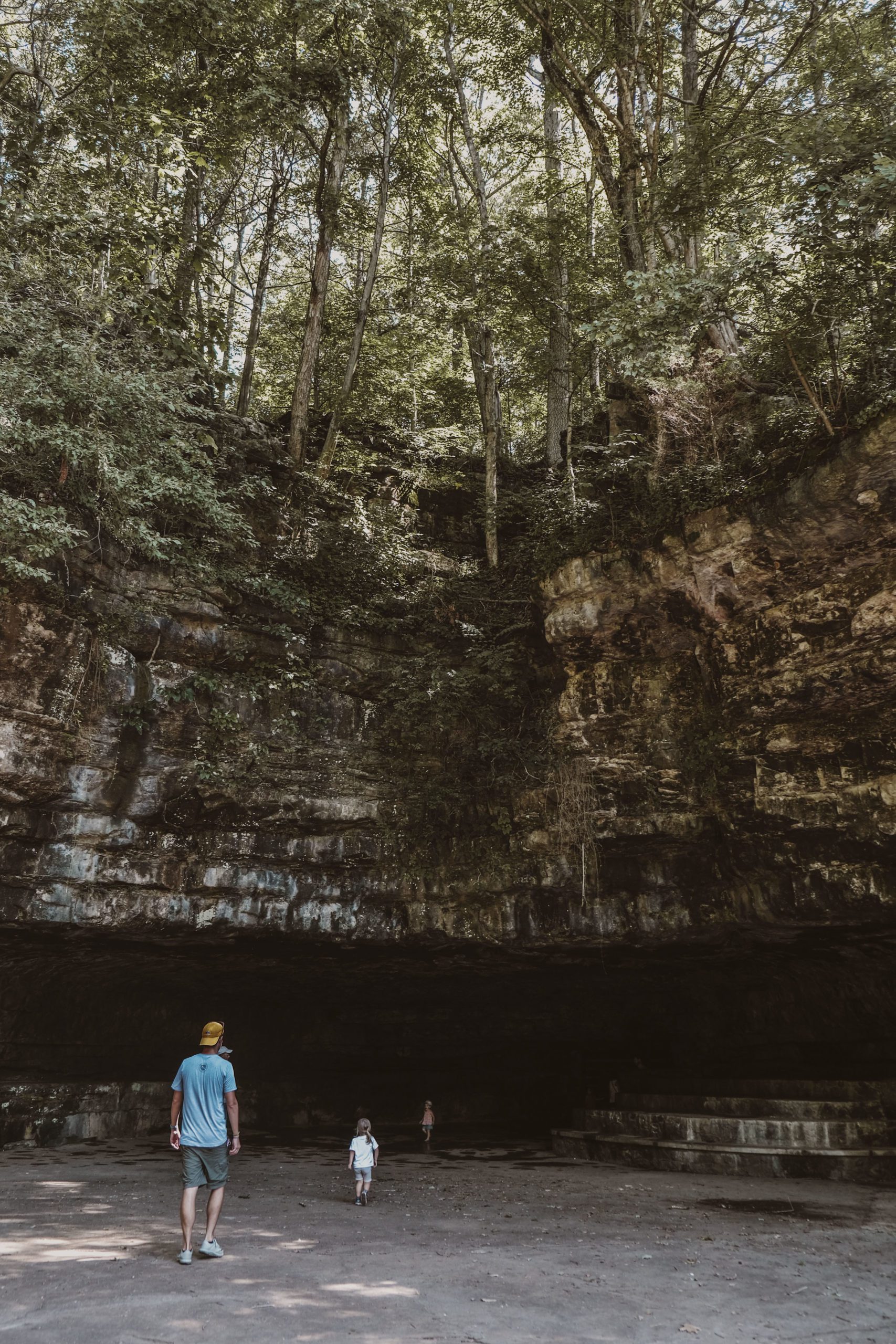
One of the most visited sites of the park, Hidden Lake, offers five different trails, most under half a mile. Combine them all and you’d still clock just under 3 miles, though it’s incredibly satisfying for such a short distance. We arrived at the parking lot off McCrory Lane and realized, “Oh, we’ve done this before” – exactly three summers ago, when I was pregnant!
There’s a surprising bit of history tied to this area; in the 1930s, Hidden Lake was a resort that offered swimming, fishing, water rides, and a clubhouse with evening entertainment. Today, you’ll find remainders of this bygone era, but it’s difficult to fully imagine a vacation-like atmosphere; foliage and brush are dense, contributing to an aura of seclusion with limited access which does not jive with its apparent one-time status as a popular summer destination.
Beginning from the parking lot, follow the Bluebird Trail through the meadow (lovely when in bloom with wildflowers) which is featured as one of the Storybook Trails currently found in many State Parks. You’ll quickly hit the start of the Ridge Loop Trail, the longest trail at the site (at a whopping 1.15 miles). This walk provides the most definitive overview of the area, leading you past several points of interest. An intersection leads to two additional trails, the Hidden Lake Trail and the Railroad Spur Trail, that you can take for quick side trips, and at some point during the journey, you’ll want to take the .25-mile out-and-back Hidden Lake Trail which leads to the shores of this historical curiosity; follow now or save it for the way down.


Continuing on the Ridge Loop Trail, the climb up the ridge is brief and manageable. I’ve read a few comments warning of the steep drop off if hiking with small children – yes, it’s there, but it didn’t feel perilous, and we had no issues or moments of concerns. (Daughter is not really one to peek over edges and seek the unknown, though.) Once at the top, you’ll be treated to a scenic overlook of this hidden oasis, tucked into overgrown vegetation. It’s the classic example of nature reclaiming the abandoned; hike on and you’ll find one of the few remainders of Hidden Lake’s resort days, a concrete dance floor perched above the waters below. Seriously – how did people get up here??
The trail continues as a loop, during which you’ll pass an old fuel tanker and the remnants of various abandoned buildings. Exit the Ridge Loop Trail and veer left to follow the second half of the Bluebird Trail, traversing through more wildflower meadows. Overall, it’s the perfect hike on the shorter side, doable with a companion of any age.


NARROWS OF THE HARPETH
Later in the summer, with in-laws visiting, Colin and I got to experience a tot-free hike for the first time in way too long. We opted to explore another of the park’s well-known hiking areas, The Narrows. The drive is another ten miles past Hidden Lake but marked profusely by road signs. It’s another site with several short trails that connect to offer a longer, more comprehensive view of the area.
We began our hike near the Harris Street Bridge, following the .35-mile Harris Street Bridge Trail south along the water. For such a short route, the scenery was fantastic. You’re hemmed in by water to your right and a towering rock face to your left, surrounded by dense, lush forest. A fork in the road indicates the end of the Harris Street Bridge Trail; take the steps to your left to climb up the .25-mile out-and-back Bluff Trail. You shouldn’t skip this one – it’s a steeper climb with gorgeous vista views carrying you the whole way up, getting better and better as you ascend. For this one, we were definitely glad to be kid-free; the path is narrow and uneven with lots of large rocks, and the drop-offs on both sides are much more precarious than at Hidden Lake. Older kids would most likely be fine.


Once you’ve descended and returned to the fork, head left down your final trail for this outing, the Tunnel Trail. It’s another short out-and-back, but this one has some history to it. The Narrows is a unique sliver of land, just a few hundred feet wide, that runs in between two portions of the Harpeth River that, by the way the river runs, are several miles apart. In the early 1800s, a businessman named Montgomery Bell used slave labor to excavate a tunnel through the ridge the separated the two river beds, then opened a forge to produce wrought iron. It operated until the Civil War and, following the war, a gristmill opened at the site using the water power produced by the tunnel.
Today, you’ll find a small waterfall and swimming hole, compliments of Bell’s tunnel. A sign orders “NO SWIMMING,” though I’m certain it is frequently ignored. I once read a warning of water moccasins in this pond, though, and, whether true or not, that’s enough to keep me out of the water forever!


There are a couple additional areas of the park worth exploring by foot that we have yet to see – Gossett Tract offers another mile-and-a-half of loop trails; Newsom’s Mill features more local history as one of the first mills on the Harpeth River; and Mound Bottom is an archaeological area dating to the Mississippian era (1000-1300 AD) managed by the state park. Clearly, just one visit to Harpeth River State Park won’t be enough.
CHECKLIST:
Date: June & July 2020
Count: 5 of 56
GETTING THERE:
Near the towns of Pegram and Kingston Springs, and just west of Nashville, all of the park’s sites are accessible from the McCrory Lane or Highway 249 exits of I-40. The parking lot for Hidden Lake is located on your left off McCrory Lane, just past the river crossing. To reach the Narrows, continue north on McCrory Lane, and turn left on Charlotte Pike/Hwy 70. Continue west on Highway 70 for another 5 miles until you reach Cedar Hill Road, and turn right. Follow this winding street north (you’ll pass Mound Bottom) until, just before you cross the river via the Harris Street Bridge, you turn right onto Harris Street into a parking lot (there’s no street sign, just a sign for the bridge ahead). There are porta-potties at the parking lots of both these sites.

Click here to read more of our adventures in Tennessee State Parks!